ArcGIS Solutions for Utilities: Understanding Stormwater Data Management
Explore a groundbreaking method for managing utility data with ArcGIS Solutions. Let's work together to unlock the potential of the stormwater data management solution. In Part 2, we configure the hosted content to get the solution up and running.
ArcGIS Solutions stands out as a beacon of efficiency and innovation in utility data management. In part one of our series, we laid the groundwork by exploring the crucial data-loading process. Now, in part two, we delve deeper into the stormwater data management solution, examining each component. Join us as we explore how this dynamic solution empowers organizations to map, edit and collaborate effortlessly on their stormwater assets. Let's continue the journey to efficiency together.
Understanding the Stormwater Data Management Solution
At first glance, the Stormwater Data Management folder in ArcGIS Online can seem overwhelming with its 21 items. However, when filtered to view the hosted feature layers, it becomes clear that only two layers power all these applications: StormwaterSystem and StormwaterMapNotes.
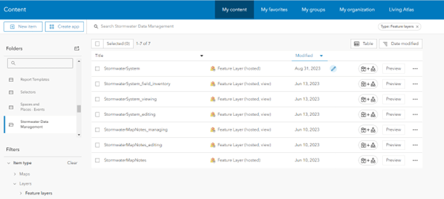
The StormwaterMapNotes layer is empty until notes are submitted through various apps, while the StormwaterSystem layer was populated in part one, meaning most of the groundwork is already done!
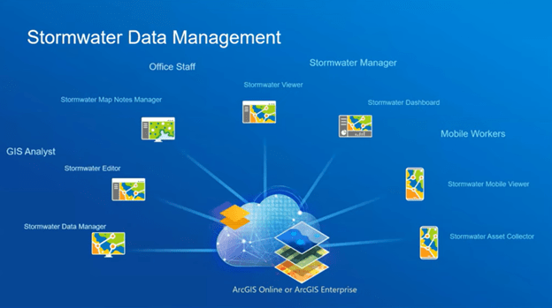
These layers feed into a comprehensive suite of maps and applications designed for all levels of staff, from field workers to upper management. The diagram below provides an overview of the solution's content, highlighting the different workgroups intended to use each application. The solution is categorized into four groups: Office Staff, Mobile Workers, Stormwater Managers and GIS Analysts. Each group has specific content to complete the asset management system. We will explore each of these categories in detail.
Managing User Access
After loading the data, the next crucial step is managing user access. This is done using the four groups created during deployment, each designed to meet the needs of the specified workgroups:
- Stormwater Editors: Contains the apps, maps and services needed to edit stormwater asset information in the office.
- Stormwater Field Users: Provides access to field applications for stormwater field users.
- Stormwater Map Notes Managers: Contains the apps, maps and services needed to view stormwater asset information in the office.
- Stormwater Office Users: Provides access to applications for stormwater office users.
Users can belong to multiple groups. For instance, a GIS analyst who collects data in the field and makes changes from the office should be a member of the Stormwater Editors and Stormwater Field Users groups. Review staff responsibilities to ensure appropriate access levels.
GIS Analysts: The Data Managers
We can delve into the solution's content with users assigned to the appropriate groups. GIS analysts play a critical role in managing the data foundation. ArcGIS Solutions provides them with two powerful editing tools:
- Stormwater Data Manager ArcGIS Pro Project: This project, used in part one to populate the StormwaterSystem feature layer, allows for easy editing of large datasets. Adding hundreds of new inlets or updating maintenance records is a breeze with its intuitive interface and pre-designed templates. Any changes made are instantly reflected in the web and mobile apps used by other teams. No additional configuration is required if the StormwaterSystem hosted feature is set as the layer source.
- Stormwater Editor Web App: As a user-friendly platform, ArcGIS Online allows for the editing of detailed data and map notes. It empowers users to make specific changes efficiently within the online system, using the same feature templates established in the ArcGIS Pro project. Editing in ArcGIS Online does not require an ArcGIS Pro license, just a user type of at least contributor.

The only necessary configuration for the Stormwater Editor web application is to set the default extent. You can set this value using the following steps:
- Browsing to the Stormwater Viewer item page and selecting "Edit Application".
- On the Map tab, zoom to the desired extent and select "Use current map view" under "Set initial extent."
- Save the changes.
The GIS analysts also have access to the Stormwater Dashboard, Stormwater Map Notes Manager and Stormwater Viewer applications through the Stormwater Editors group. The main uses of these applications are designed for other workgroups; we will discuss these in more detail as we look at those groups.
Mobile Workers: The Field Data Collectors
With firsthand knowledge of field conditions, field workers are essential to asset management. The Stormwater Field Users group provides them with two key mobile tools:
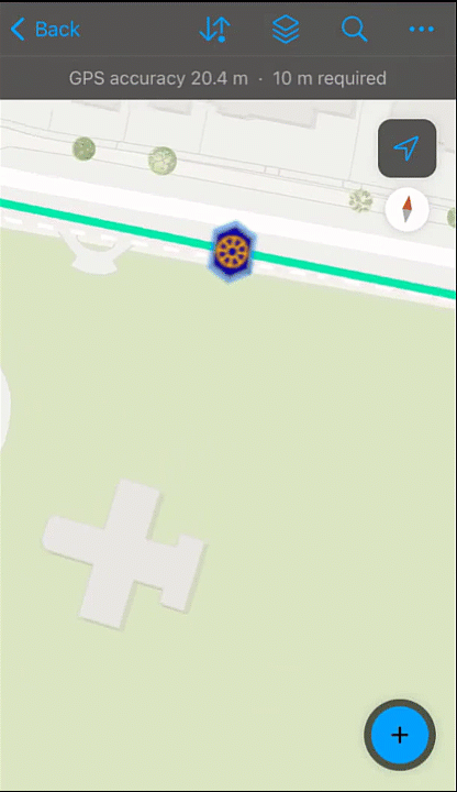
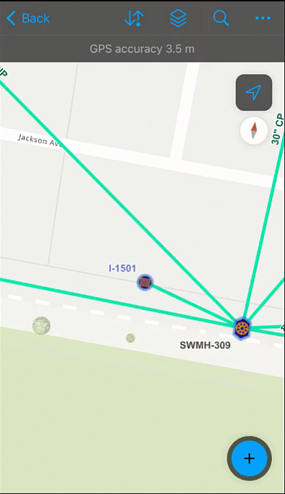
- Stormwater Asset Collector Map: Integrated with ArcGIS Field Maps, this tool allows field workers to capture location data accurately, collect detailed attribute information and work offline. It ensures data collection continues uninterrupted in remote areas and synchronizes once back online. This map is automatically ready for use in ArcGIS Field Maps; however, I recommend you open it in the Field Maps Designer, where you can customize the form and configure default values. It is also recommended that you set the default extent for the map and create offline areas for a better end-user experience. With everything configured the way you want in the map, you can open it on your mobile device and begin collecting and editing assets.
- Stormwater Mobile Viewer Map: This map helps workers locate assets and view contextual information. It is not intended for data collection or editing but for viewing existing asset information. The map also allows them to contribute notes and alert office staff to any issues observed in the field. Once again, no additional configuration is required to use this map in ArcGIS Field Maps; however, it is recommended that you review the settings in the ArcGIS Field Maps Designer and set the default map extent.
If there is any chance your mobile workers will be located in or near hazardous areas, consider adding geofences to alert workers of potential risks.
Mobile workers also have access to the Stormwater Viewer application through the Stormwater Field Users group; we will look at this application in more detail below.
Stormwater Managers: Strategic Decision-Makers
The Stormwater Managers group equips those responsible for strategy with tools for informed decision-making. This group contain two main applications to facilitate their work:
- Stormwater Viewer: This interactive web application provides a comprehensive view of the stormwater network, offering insights through thematic maps, dynamic legends and detailed asset information. It contains all existing assets in the system for easy viewing from any workstation.
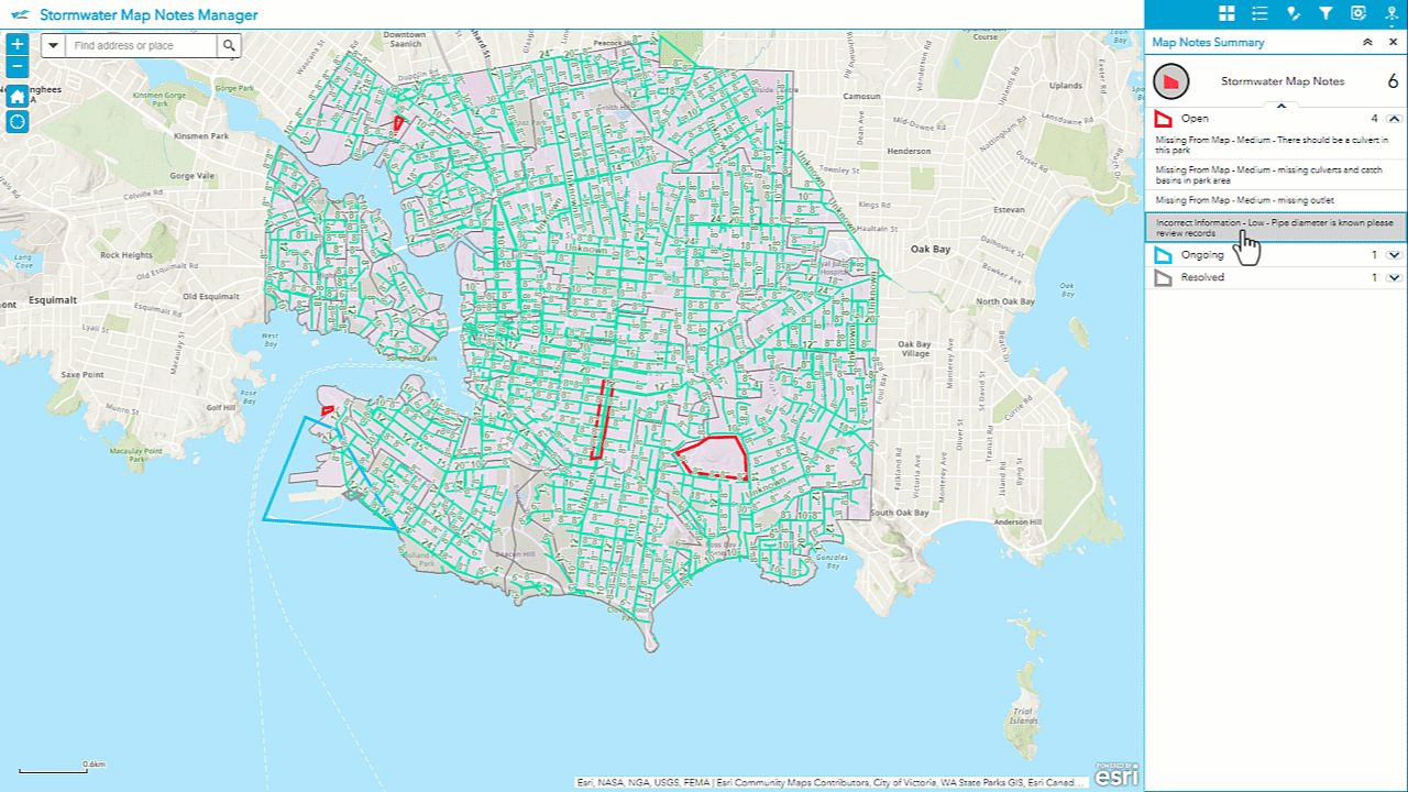
- Stormwater Map Notes Manager: This web app facilitates communication, allowing managers to review and manage map notes, prioritize tasks and track note resolution status. Any notes made by data editors or mobile workers alerting to issues with the data can be seen here. Managers can also create new notes to delegate tasks to their staff.
As with the Stormwater Editor application, the only configuration required for these applications is to set the map extent using the same steps shared previously.
Office Staff: Streamlining Daily Operations
Not every staff member interested in stormwater assets needs to be able to see each feature and make edits or notes on the data directly. This is where the Stormwater Office Users group and our final workgroup of Office Staff, comes into play. The key feature of this group is the Stormwater Dashboard, a real-time interface providing key performance indicators (KPIs) along with charts and graphs to identify trends and track progress.

While there is no inherent need to change the configuration of this application before it can be used, the dashboard allows for the customization of all the solutions' applications. Every organization will be interested in different metrics; you can update the indicators and charts to show the fields most relevant to your workflows. 
Office Managers can also access the stormwater viewer application through the Stormwater Office Users group if they require a more detailed view of the assets.
With the Stromwater Dashboard configured, we have seen all the features included in the stormwater data management solution and are ready to start working.
ArcGIS Solutions offers a powerful and user-friendly solution for stormwater data management, empowering organizations to streamline operations and make data-driven decisions. With minimal configuration required, you can hit the ground running immediately or push the applications further with full customization. The Stormwater Data Management solution provides a comprehensive set of tools for all levels of staff, from field workers to upper management.
GIS analysts benefit from powerful editing tools that synchronize data across all platforms, field workers can capture and edit data seamlessly even in offline environments and managers can make informed decisions with up-to-date insights from dashboards and viewer applications. This cohesive system facilitates effective data management and fosters collaboration across different workgroups, ensuring everyone is on the same page.
Ultimately, ArcGIS Solutions demonstrates how advanced technology can transform utility data management, offering both immediate usability and the potential for tailored customization. By leveraging these tools, organizations can enhance their operational efficiency, improve data accuracy and make more informed decisions, paving the way for a more effective and responsive approach to stormwater assets.
Looking Ahead: The Future of ArcGIS Web AppBuilder
You may have noticed that most of the applications in this solution are built using ArcGIS Web AppBuilder in ArcGIS Online. For those not aware, ArcGIS Web AppBuilder will be retired in the fourth quarter of 2025. Although existing applications will work until then, solutions will be updated with newer applications as retirement approaches. Keep an eye on the What’s new in ArcGIS Solutions page for updates.