App-ily Ever After: The Success of Saint-Hyacinthe’s Géoportail
Discover how a small yet dedicated geomatics team in Saint-Hyacinthe, Québec, transformed their city's digital landscape with the launch of their innovative Géoportail hub.
In early 2023, the Ville de Saint-Hyacinthe, Québec launched their brand-new ArcGIS Hub site, aptly named “Géoportail” on their municipal website. This hub was created with the mission to share important applications with the citizens of Saint-Hyacinthe in a unified and accessible manner and to promote the key role that GIS plays in information dissemination. Little did they know that this would soon set off a domino effect of further app creation through citizen and staff engagement.
Like many municipalities across Canada, Saint-Hyacinthe's geomatics team is a small but dedicated one. As a team of just two, it is paramount for them to leverage as much technology as possible to ease their efforts and streamline their workflow to keep up with the requests they receive from their city and citizens. What distinguishes Saint-Hyacinthe from other cities is its influence in the agricultural and technological domain. Saint-Hyacinthe is well-known for being an agri-food, veterinary and agri-environmental biotechnology hub (link), and has many educational campuses, enterprises and technical parks within the city limits and beyond. Their municipal identity as a technopole is evident in their GIS initiatives: the geomatics team has expanded its responsibilities to encompass the diverse range of industries that have established themselves in Saint-Hyacinthe.
The creation of maps and applications for municipal and industrial uses has evolved significantly in recent years. The city’s website previously contained static PDF maps and embedded hyperlinks to basic applications – a far cry from where they are today, with a plethora of interactive web apps now located within their hub site. Their GIS team also received multiple complaints due to incorrect features and labelling due to errors found in other basemaps. To address this, the geomatics coordinator, Jeffrey Lafleur, began generating and maintaining a custom basemap of Saint-Hyacinthe himself. However, the process was tedious and expensive, especially as his inventory of applications grew and demanded more of his attention.
Enter the Community Map of Canada: upon hearing about the program in 2021, Jeffrey Lafleur swiftly made his first data contribution to the basemap. He immediately understood how contributing to the Community Map would drastically reduce his workload, while also ensuring that it would allow all his applications to use an authoritative and uniform basemap.
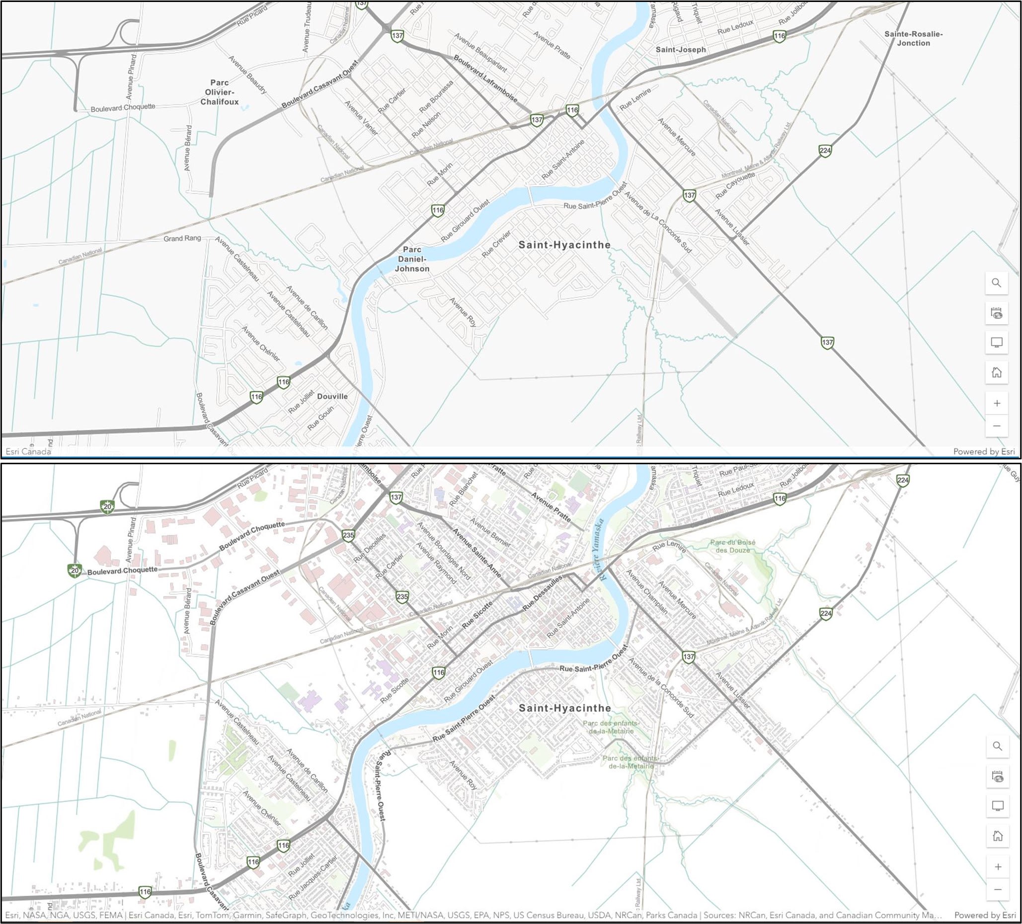
A comparison between the Ville de Saint-Hyacinthe on Community Map of Canada Topographic basemap before data -contributions (top) and after they contributed data to better-represent their community (bottom).
He subsequently set the Light Grey Community Map as his organization’s default basemap (as this style allows his other data to stand out) and continued providing frequent data updates to the basemap. With his basemap all sorted by the Community Map of Canada team, he could now focus on a bigger project: creating the city’s ArcGIS Hub site.
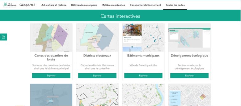
The Ville de Saint-Hyacinthe’s ArcGIS Hub “Géoportail,” containing more than 20 dynamic maps and applications available to the public. Some examples of applications include an electoral districts map, a municipal buildings map, and a map showing winter snowplowing.
The idea of having an ArcGIS Hub site stemmed from the desire for the geomatics team to have complete control over the design, deployment and integration of a site – without having to rely on the city’s main website developers. In this way, Jeffrey and his coworker, Francis Pelletier, were able to quickly and continuously add applications and maps to their Géoportail and customize it to their liking. The creation of their site was made easy by the ready-to-use templates and seamless integration of the apps hosted in their ArcGIS Online organization.
Their cartographic hub not only achieved their technical goals but also kickstarted an era of collaboration between the city’s other departments, citizens and geomatics team. Everyone was appreciating the utility of incorporating spatial data into web applications and with this came an outpouring of ideas for Jeffrey and Francis to run with. Soon enough, they would be receiving all kinds of app requests – from an app that showed prime fishing locations, a dynamic survey of citizens’ opinions and perspectives on the city, a map showing the locations of the city’s technological assets (printers), to an app showing the best places to watch the upcoming Saint-Jean-de-Baptiste fireworks! Since its launch in June 2023, their Géoportail has been a helpful place to group all their applications together.
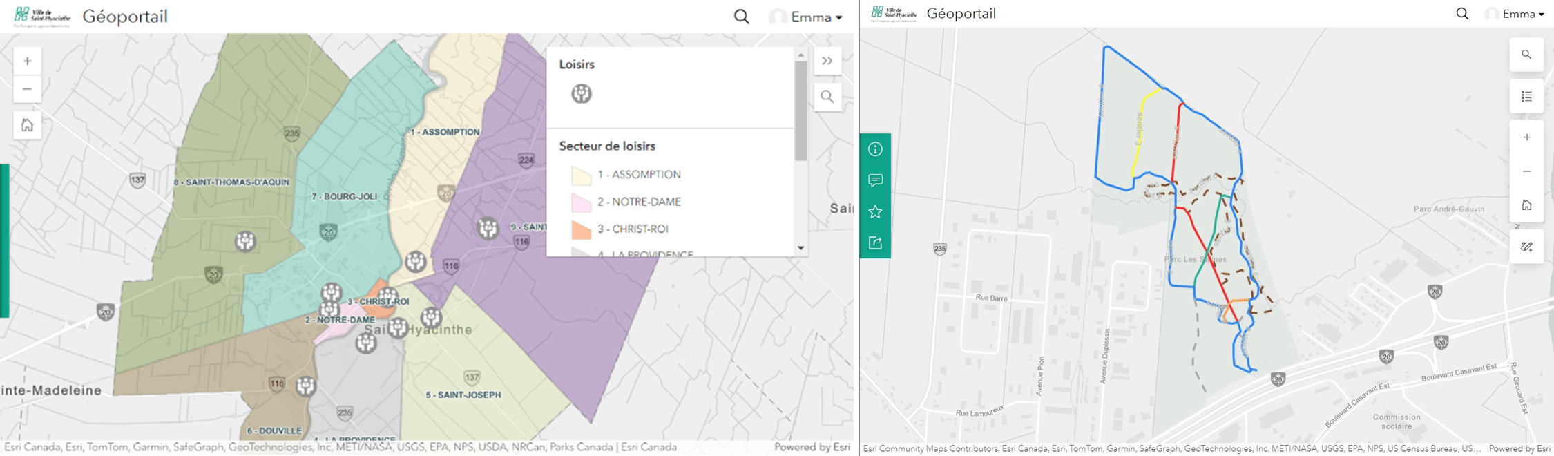
Recreation area and park trail apps featured on the Ville de Saint-Hyacinthe’s Géoportail.
Regarding the involvement of the Community Map of Canada, it was now also used as the default basemap for internal applications and projects used by other staff, making it easy to ensure that all users are seeing and using the same authoritative and accurate community data, straight from the source. Non-GIS users like having a basemap ready to go for easy use and Jeffrey enjoys the newfound ease of having his data integrated in a basemap without having to build it himself. Further, given the centralization of all apps in this hub, the hub has even allowed other departments to streamline their workflows; in some cases, a simple app has replaced Excel spreadsheets.
The Géoportail also became a topic of conversation among other GIS professionals across Québec when Jeffrey shared their GIS journey at the most recent French Happy Hour/ 5 à 7 hosted by the Community Map of Canada program. After listening to Jeffrey’s technical GIS journey and having had a chance to have participate in a Q&A and networking session during which participants exchanged ideas, other communities left the event feeling inspired – perhaps to one day create a Hub site of their own.
Given the momentum of their GIS journey so far, passion, and technopole identity, what are some of the ideas and projects that the Saint-Hyacinthe GIS team have in store for the Géoportail, you may ask?
Jeffrey and Francis will continue their already-strong collaboration with the Community Map, continuing to frequently send in their data updates for integration on the basemap. They also want to develop an internal-facing side of the hub site to have a section for employees only (it is currently aimed externally at citizens). Eventually, they would like to use the ArcGIS Vector Tile Style Editor to create some custom symbology that would simplify the appearance of the Community Map of Canada for use in particular apps and use cases, for accessibility considerations and for sharing to social media.
True to their identity as a technopole, and in alignment with their motivation and dedication as a small but mighty GIS team, there is no doubt that the ArcGIS Hub Site of Saint-Hyacinthe, Québec, is just another one of many chapters in the GIS journey of Jeffrey Lafleur.
This article was written with support from Community Map of Canada colleague Emma Melis.