Uncovering the legacy of Indigenous residential schools through GIS
Dr. Sarah Beaulieu and Indigenous communities use high-accuracy location and mapping technology to map unmarked burial sites. This is one example of how GIS technology supports efforts at former residential school sites to uncover truths and advance Truth and Reconciliation across Canada.
![]()
Dr. Sarah Beaulieu prepares to use the Eos Arrow 100® Global Navigation Satellite System (GNSS) receiver with ArcGIS Field Maps to collect submeter-accurate locations of each grave identified by the ground penetrating radar (GPR) system.
In 2021, Dr. Sarah Beaulieu, assistant professor in Anthropology and Sociology at the University of the Fraser Valley, alongside the Tk’emlúps te Secwe̓pemc First Nation, discovered more than 200 anomalies representing possible unmarked graves of Indigenous children at the site of the former Kamloops Indian Residential School. The discovery kicked off a call for similar surveys to be done at other former residential school sites across Canada. This blog post highlights the significant role of GIS mapping solutions in addressing the historical truths, legacy and impact of Indigenous residential schools in Canada.
Residential schools represent a tragic period in Canadian history, where Indigenous children were forcibly removed from their families, stripped of their language and subjected to cultural assimilation. Dr. Beaulieu collaborated with Indigenous communities on an initiative using remote sensing, Eos Positioning Systems and Esri Canada technology to survey the landscape around former residential school sites. This involves using ground penetrating radar (GPR), high-precision GPS and ArcGIS to map and document the locations of suspected unmarked graves.
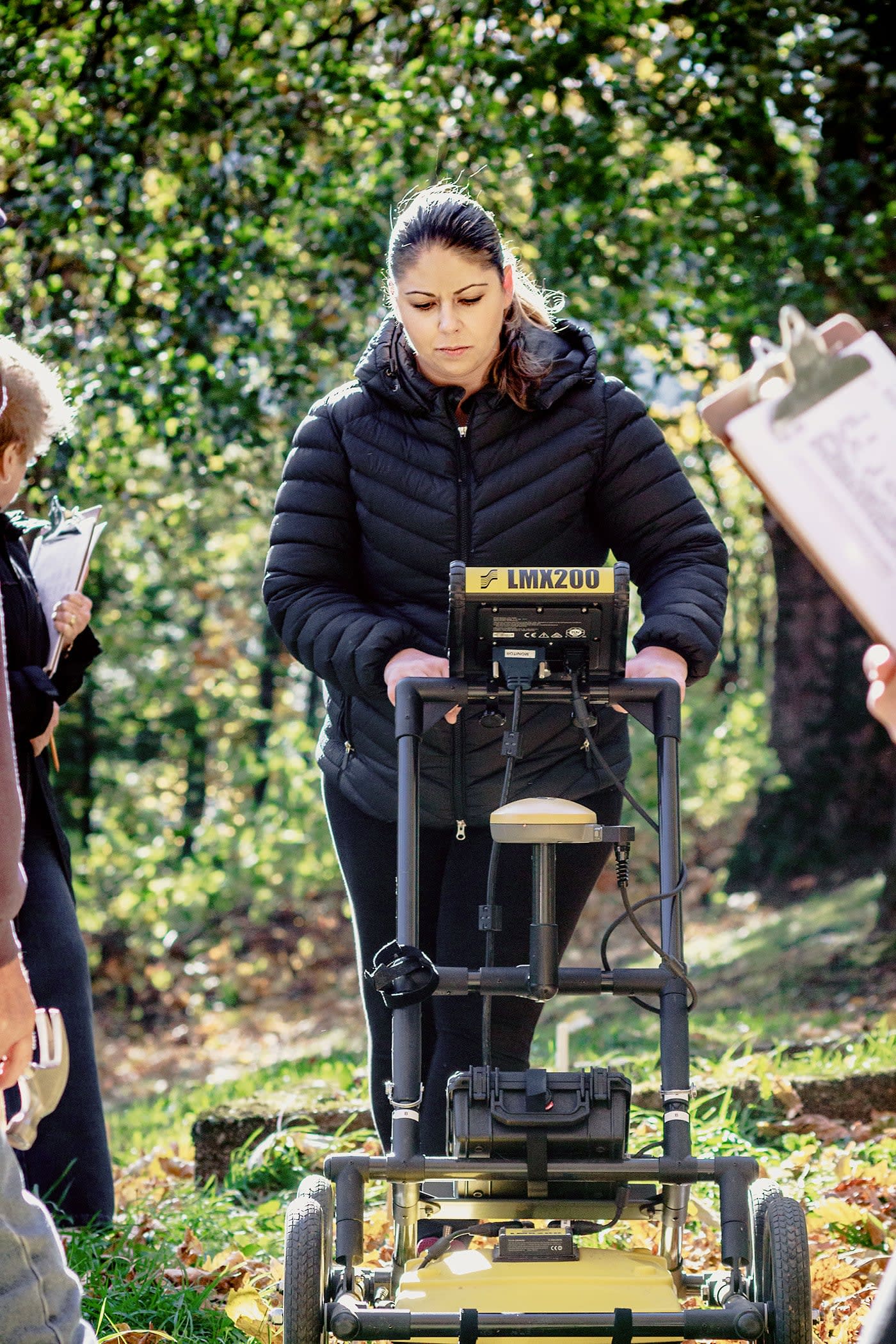
Dr. Beaulieu uses the Radiodetection® LMX200™ GPR to survey a potential gravesite on Indigenous Residential School grounds.
Mapping and documenting unmarked graves at residential school locations provides a crucial avenue for healing, acknowledgment and reclaiming of Indigenous histories and cultural heritage. This initiative supports Indigenous communities to assert control over their narratives, ensuring that the voices of those impacted by residential schools are heard and honoured while respecting Indigenous community privacy.
Collecting and analyzing data
Using the extensive GIS capabilities offered by Esri's ArcGIS Field Maps, the project involved the collection, integration and analysis of various data sources, including historical records, archival maps, survivor testimonies and oral histories. Esri Canada facilitated the creation of comprehensive visualizations and interactive tools that provide an in-depth understanding of the locations, histories and stories associated with residential schools across the country.
“Communities need to come together to decide what these next steps will entail — but this takes time. Using a high-accuracy GPS unit enables us to mark in the targets (anomalies) knowing that when each community is ready to continue with future work, they will be able to return to the precise locations and continue on.” – Dr. Sarah Beaulieu, Assistant Professor in Anthropology and Sociology at the University of the Fraser Valley
The Field Data Collection App developed through this endeavour is a crucial resource for residential school survivors, families and researchers. It enables access to accurate and reliable information about residential schools, thereby fostering awareness, education and a deeper understanding of the lasting impacts on Indigenous communities. Furthermore, the GIS platform assists in locating unmarked burial sites, aiding efforts to honour and remember the children.
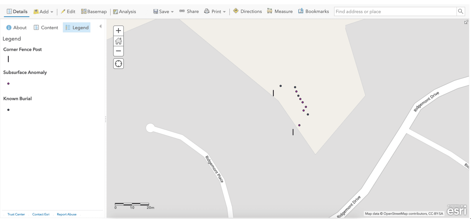
This ArcGIS Online screenshot shows GPR grave locations at a previous project of Dr. Beaulieu's, collected with ArcGIS Field Maps. Using the app paired with an Arrow 100 GNSS receiver, she can obtain high-accuracy locations of the anomalies with GPR.
Results
Esri Canada's GIS technology plays a part in truth and reconciliation processes. By accurately mapping and documenting sites like former residential schools, Indigenous peoples can reclaim their narratives, validate oral histories and commemorate the lives lost. GIS enables Indigenous communities to record these landscapes in a different way that brings together both Western science and Indigenous Ways of Knowing, facilitating informed decision-making, land management and advocacy efforts.
The GIS-based solution developed through this effort not only provides a comprehensive resource for education and healing, but also is a means of asserting Indigenous sovereignty and advocating for justice and reconciliation. Esri Canada's commitment to ethical engagement with Indigenous communities underscores the transformative potential of GIS technology in promoting social justice and contributing to a more inclusive society.
Resources
• Eos full case study - Mapping Unmarked Graves at Indigenous Residential Schools
• Global News press conference with Dr. Sarah Beaulieu on July 15, 2021
Learn more about Esri Canada’s work with Indigenous peoples.
Esri Canada Indigenous Peoples page. Learn more about our collaborations and GIS solutions with Indigenous communities from coast to coast.
New to geographic information system (GIS) technology?
Find out What is GIS?
*Dr. Sarah Beaulieu is not sponsored by Esri Canada.*
A special thank you to Kelsey Davis, Program Manager, Indigenous Communities, for co-authoring this blog post.