Embracing User Types: Unlocking the Benefits of Adopting Named Users
I am answering your questions from our “Embracing User Types: Unlocking the Benefits of Adopting Named Users” webinar. In this blog post, I will cover the best ways to navigate these newly available user types.
Understanding the user type model can be one of the most important things when trying to create new maps and applications within your organization. There are various user types with many different functionalities. It is important to note that with these user types, as your administrator changes your user type and role, your functionality and application availability may change.
For a recap of what we covered in our recent webinar on this topic, watch the webinar recording here.
User Types Update June 2024
The Named User licensing model was first introduced many years ago. This model corresponds directly to the user types that you can have available to use within your organization. In the ArcGIS Online update in June 2024, the naming and functionality of these user types was updated to help streamline the options available for administrators.
The updated user types are listed as shown below:
- Viewer
- Contributor
- Mobile Worker
- Creator
- Professional
- Professional Plus
For those familiar with the old user type model, we can notice as shown in the naming above that there have been some slight changes to the names. Along with these changes in naming, there have also been some changes in functionality for some of the user types. The diagram below shows the comparison between the user types that were available before and after the June 2024 update that occurred.

With these new user types, we highly encourage all users to start their transition to ArcGIS Pro if they have not already. Though they still can host and create their content in ArcMap, we encourage this transition, as most of the updates in ArcGIS Online now correspond to ArcGIS Pro rather than ArcMap. An example of this is how the updated user types, specifically the creator, professional and professional plus tiers provide you with different versions of ArcGIS Pro.
To start using these user types, please ensure that your administrator sets up your account with the corresponding user type that you need to proceed with the functionality you require in the software.
This functionality matrix highlights the key differences between the capabilities of each user type. An important detail to note is that each user type possesses all the capabilities of the user type that comes before it, so as you move up the scale, you won’t lose functionality or capabilities. We will now go through these to see what each level has to offer you and your organization.
Viewer
The viewer user type is the first and most basic user type available to use as a member in an organization, giving you access to view content created by other users. With this, you can open any application that has been created and view its contents along with use it, to some extent. This means, you can view it, but not edit the dashboard.
An example would be if you had a colleague who created a dashboard about wildfires using ArcGIS Dashboards. Since this dashboard has been created and shared with you by the owner, you can open it, view its content and use the widgets and functionality built into the dashboard. At this point, you cannot alter the dashboard and/or add in new content to it.
Contributor
For our next user type, this is where you will start to experience some of the changes that occurred with this update. The old user type at this level was known as the ‘Editor’ user type and has now changed to ‘Contributor’. The naming is one of the major changes for this level. Users can also interact with data from ArcGIS Microsoft 365 and ArcGIS GeoBIM. Although, when it comes to the functionality, the majority remains the same as it builds on and includes everything from the viewer. As a general overview, the Contributor user type helps expand capabilities from the existing Editor user type.
Mobile Worker
The Mobile Worker user type includes all the previous functionality of the Contributor while also giving you access to three field applications. These applications include : ArcGIS QuickCapture, ArcGIS Survey123 and ArcGIS FieldMaps.
As an additional component to this user type, you also have access to use ArcGIS Workforce which is a application that integrates a work management solution to help coordinate and effectively analyze your field workforce.
Creator
The Creator user type is where things change at a larger scale. This user type includes everything from the Mobile Worker and builds onto it, allowing users to create their own content and applications in either ArcGIS Online or ArcGIS Enterprise. In other words, you get access to almost everything at this level in terms of applications (View the matrix to see which applications this applies to) and you now also get access to an ArcGIS Pro Basic license. This will give you the opportunity to now work in ArcGIS Pro and have the access to edit and analyze data in a more comprehensive way by utilizing the data management tools available to you. Alongside ArcGIS Pro, this also includes access to ArcGIS Image for ArcGIS Online and ArcGIS Excalibur. These were previously add-on licenses that were needed which are now automatically included as part of the creator user type. This user type expands on the previously existing GIS Professional Basic user.
Professional
The user type that follows after the Creator is the Professional. This user type includes all the same functionality as the Creator. A professional user type also has the ability to access the capabilities of ArcGIS Pro Standard. This version of ArcGIS Pro will allow users more flexibility when it comes to using things like the Utility Network toolbox, creating mosaic datasets and the use of many more features. This user type expands on the previously existing GIS professional standard user type.
Professional Plus
The final user type is Professional Plus. This user type has all the functionality of the Professional user type and builds on the previously existing GIS Professional advanced user type. The Professional Plus user allows you to have access to ArcGIS Pro Advanced.
Not only do you get access to the most advanced version of ArcGIS Pro, but you now also have some of the most used ArcGIS Pro extensions some of which include:
1. ArcGIS 3D Analyst
2. ArcGIS Image Analyst
3. ArcGIS Spatial Analyst
For those users who also look to make 3D designs of cities, you now also have ArcGIS CityEngine which is included in this user type.
This was a quick overview of what the new user types look like and what each level includes.
Frequently Asked Questions:
Now, we will discuss some frequently asked questions regarding these user types and answer some questions from the webinar.
Q: Are concurrent use licenses still being supported?
A: This licensing change will not impact your existing Single or Concurrent use licenses for ArcGIS Desktop. Unless the licenses have expired, they will continue to function as they do currently.
Q: Is ArcGIS Data Pipelines included in all user types to be used?
A: ArcGIS Data Pipelines allows you to connect to and read data from where it is stored, perform data preparation operations and write the data out to a feature layer that is available in ArcGIS. This provides data integration by having the ability to construct and run data preparation workflows. As we know, Data Pipelines is currently only available in ArcGIS Online. For this to be used, you must have a minimum of a creator user type. This means that Data Pipelines will not be available with viewer, contributor and mobile worker user types.
Q: When can we expect to see these changes in ArcGIS Enterprise soon and how will they be implemented?
A: The changes to the evolving user types have occurred in the June 2024 ArcGIS Online update. When it comes to ArcGIS Enterprise, we can expect these changes in version 11.4. At this time, this version is set to be released sometimes in November 2024. Please stay updated for more updates as this release of ArcGIS Enterprise gets rolled out.
Q: Since these user types have already taken effect, how do I proceed with changing these for users in my organization?
A: As soon as the update occurred in ArcGIS Online, all administrators will have gotten a message about it. It gives more information about the user types and shows you how to change them. When the update has happened, some add on licenses may still be applied to specific users. The following message will appear.

With the changes to the user types, please note which add on licenses need to be unassigned after the update and go through to make the corresponding changes. These changes can be done using the menu shown in the screenshots below which can be accessed by pressing “unassign duplicate add-on licenses”.
As shown above, the menu shows my account has a duplicate license assigned to it. This is because the Professional Plus user types now include ArcGIS Pro Advanced, so the standard version that was manually assigned to me previously is no longer needed.
To fix this issue, simply navigate the menu shown below and go through the licenses for all members in your organization. Please note that only duplicate assigned licenses will appear here.
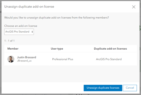
By then selecting the ‘Unassign duplicate licenses’ option, all duplicate licenses will be removed for the corresponding product selected. This must be done for all add-on licenses and will help you also better manage your licenses.
This covers a lot of information regarding the user types in the ArcGIS Online June 2024 update as well as most commonly asked questions throughout the webinar. Stay tuned for more updates!