A living map of the Bow River watershed
The Bow River Basin Council has developed an interactive version of their State of the Watershed report that’s influencing thousands of Albertans to connect with their environment.
The Bow River Basin Council (BRBC) is a charitable organization with a mandate to help nurture, share and protect the waters of Bow River Watershed, which has its source in the Bow Glacier in the Canadian Rockies. The river flows east through Banff and Canmore, south through Calgary and finally joins with the Oldman River in southeast Alberta. Home to a population of over 1.3 million, the river basin is an important source for agriculture and hydroelectric power, as well as a site for recreation for many Albertans. The BRBC is one of 11 Watershed Planning and Advisory Councils (WPAC) in the province and is supported both volunteers—more than 800 of them—as well as a small core staff.
“I don’t just work at the BRBC, I also grew up in southern Alberta,” says Brooke Kapeller, program coordinator for the BRBC. “I was always paddleboarding, kayaking and going out with my dog to explore in the summers. So I want to do what I can to connect others with the Bow River and get them involved.”
Keeping up with changes in the watershed
As a WPAC, one of BRBC’s mandates is to produce a State of the Watershed (SOW) report every five to ten years. SOW reports allow the BRBC to understand what’s going on in the basin and are used by a variety of stakeholders, including water managers, decision makers at the municipal and provincial levels, and members of the public with an interest in the Bow River Basin. These reports can also be used as an information source for actionable watershed management plans.
The BRBC produced their most recent full report in 2015 in a push that required significant effort and volunteer hours, but this static report soon became dated and required updating.
The effort required to produce previous SOW reports led the BRBC to look for ways of reporting information about the watershed that would allow the BRBC to make continual updates as new data became available. Not only would this allow changes in the watershed to be monitored more closely, but it would also reduce the burden of a big push every few years, leading to better use of volunteer and staff time.
A complete view of the watershed that can be updated any time
Brooke and the BRBC chose ArcGIS Experience Builder as their tool for developing the 2025 State of the Bow River Watershed (SOW) Report. Experience Builder is a low-to-no-code tool for building interactive experiences powered by geographic data, making it the perfect solution to help the BRBC ease their reporting workflow and engage a diverse stakeholder base.
The new Experience Builder application can be updated anytime, allows users to pursue different levels of detail depending on their interests and expertise, and includes interactive maps that allow users to pinpoint their location within the watershed.
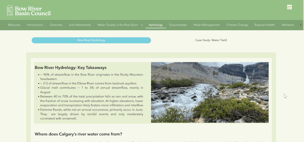
The BRBC’s State of the Watershed (SOW) Report, built in ArcGIS Experience Builder, allows users to find information about the Bow River watershed easily and quickly.
A report that can be updated any time
The BRBC SOW Report is a living resource that is being developed continually. For example, rather than developing a fresh document every time they want to update the report’s water quality section, the BRBC can simply re-run the analyses for that section of the report and update the Experience Builder application.
A complete picture that enables different levels of understanding
The BRBC SOW report app allows stakeholders to understand the watershed at whatever level works for them. The BRBC has the special challenge of needing to communicate SOW information to a wide variety of stakeholders with different levels of expertise, all in one place. Using Experience Builder’s tabs feature and its multimedia embeds allows the BRBC to do exactly this. If users want a high-level understanding, they can explore the app’s interactive maps and overviews. If they want to go in-depth on a particular topic, they can follow the provided links to other sources or more detailed reports produced by BRBC members and partners.
The BRBC’s SOW Report contains information relevant to water managers and decision makers, but it also provides educational information for those who are less familiar with watershed science—like this carousel describing the different types of wetlands.
Interactive maps that increase public engagement
Thanks to Experience Builder’s ability to embed interactive maps, users can zoom in to where they live to better understand familiar parts of the watershed.
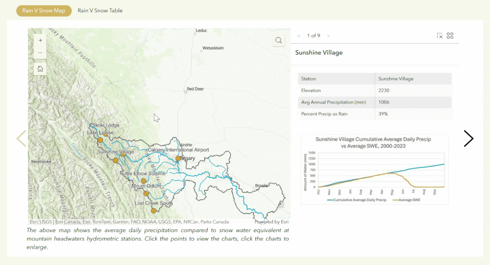
The BRBC has used interactive maps to allow report users to place themselves within the Bow River watershed and get more data about hydrology in their area.
The report also covers sub-watersheds within the overall Bow River Basin, allowing users to connect with local Watershed Stewardship Groups—many of whom have Experience Builder apps of their own that are linked within the BRBC’s report, summarizing the State of the Watershed at the smaller sub-watersheds scale.
“Experience Builder has allowed us to make the report more user-friendly. Putting it online and using interactive features means people can ‘choose their own adventures’, explore the areas that interest them and then follow links to our partners and members’ information, that can help them understand the topic or specific region further.” —Brooke Kapeller, program coordinator, Bow River Basin Council
Growing an engaged watershed community
Because the app is a living resource, the BRBC’s staff and volunteers are working continually on adding to it. As of this writing, their next planned step is to add chapters about land cover and native prairie and invasive species to the app to expand its capabilities.
Feedback on the app from the BRBC’s community has been overwhelmingly positive. Users of the app have praised the app’s modern interface, quality of data and breadth of geographical coverage. They’ve also discussed using it as a classroom teaching tool.
The SOW Report app has also been shortlisted for an Emerald Award. The Albera Emerald Foundation, which hosts the awards, has a mission to accelerate environmental excellence by celebrating Alberta’s environmental leaders and sharing best practices. Nominated in the Emerald Award’s Water category, the BRBC’s SOW Report app has influenced thousands of Albertans—whether they’re volunteering with the BRBC directly, or whether they’re among the 6500+ views the app garnered in its first few months.
It’s all part of a greater story: people want to get more involved with the Bow River Basin and deepen their understanding of their relationship to the environment, and the SOW Report app is giving them an up-to-date, comprehensive picture of the Bow River Basin that’s helping them do that.
“To me it’s just really inspiring that there are so many people who care to volunteer their time,” says Kapeller. “The biggest strength of the organization is in the membership and the passion of the people involved.”
Want to learn more? Connect with the BRBC, explore the possibilities of ArcGIS Experience Builder for yourself and discover other ways that conservation groups are using geospatial technology to engage people.