GeoAI empowers utilities: A smarter future for infrastructure management
Esri ArcGIS helps utilities model and manage infrastructure with a real-world, detailed view of their assets. With GeoAI, you can automate tasks, boost efficiency and make smarter, data-driven decisions.
We designed ArcGIS as an enterprise GIS platform to help utilities manage their assets and workflows more effectively across their service territories. Whether it’s electric, gas, water or telecommunications, ArcGIS supports multiple utility domains and enables organizations to build scalable, real-world models of their infrastructure networks.
Utilities around the world have adopted ArcGIS to support a wide range of operational needs. At its core, it helps maintain a comprehensive asset inventory and documents on how assets are interconnected within the network. With this foundational data in place, utilities can easily share information and deploy applications across the organization, improving decision-making in the field, in the office and with stakeholders.
Since ArcGIS is built on open IT standards, it integrates smoothly with other business systems. That means you can bring location intelligence into all kinds of business processes.
Now, with rapid advancements in artificial intelligence (AI), we’re entering a new era. By combining GIS and AI (GeoAI), we’re unlocking smarter, faster and more predictive insights for managing utility infrastructure.
What is GeoAI?
Geospatial Artificial Intelligence (GeoAI) is the integration of artificial intelligence (AI) with spatial data, science, and geospatial technology to better understand complex, real-world conditions. When applied within Esri technology, GeoAI empowers organizations to automate workflows, uncover patterns and model future scenarios, enabling smarter, data-driven decision-making.
GeoAI is already helping organizations in a variety of ways to support analysis and improve the automation of tasks. From intelligent feature extraction to predictive modeling, GeoAI is transforming how spatial data is used.
For utility organizations, the impact can be significant. GeoAI can:
- Automate asset inspections using imagery and sensor data
- Predict maintenance, infrastructure failures and outages before they occur
- Manage vegetation-related risks through advanced image analysis
- Improve data quality and accuracy by identifying anomalies and inconsistencies
By embedding GeoAI into spatial workflows, utilities can move from reactive to proactive operations, saving time, reducing costs and improving service reliability.
How GeoAI enhances utility operations
GeoAI is reshaping how utilities operate by introducing intelligent automation and predictive capabilities across key workflows. Here are four impactful ways GeoAI is driving operational excellence:
1. Predictive maintenance and outage response
Utilities can use Esri’s GeoAI capabilities, such as deep learning tools in ArcGIS Pro, ArcGIS Notebooks, ArcGIS Image Analyst, and web mapping applications, for preventative maintenance and outage response. These tools help analyze asset data, environmental variables like soil conditions and weather patterns and real-time sensor inputs to detect early signs of potential failure.
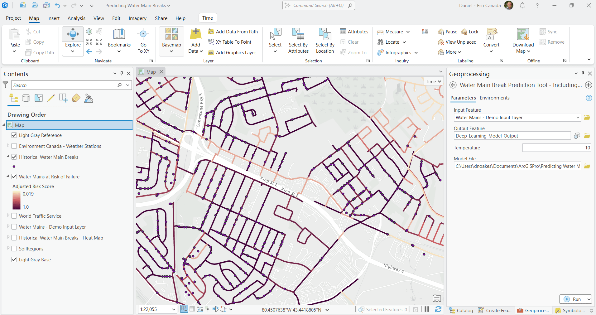
GeoAI-powered detection of water main breaks and pipe failures in ArcGIS Pro means faster insights and smarter response time. Source: Kitchener GeoHub
This proactive approach enables utilities to plan maintenance and inspections before issues escalate. It helps reduce unplanned downtime, lower repair costs and speed up field response, ensuring greater reliability across the network.
2. Vegetation management planning
Managing vegetation near critical infrastructure is a constant challenge for utilities. With GeoAI, it’s easier to stay ahead of risks. By using imagery, including Light Detection and Ranging LiDAR), deep learning and spatial analysis, utilities can process large volumes of data to identify vegetation encroachment risks.
GeoAI helps teams detect hazards early, prioritize risks based on severity and even predict how vegetation will grow over time. This makes it easier to plan trimming or removal before problems occur. By optimizing vegetation management plans, utilities can reduce maintenance costs, prevent equipment damage and deliver more reliable service.
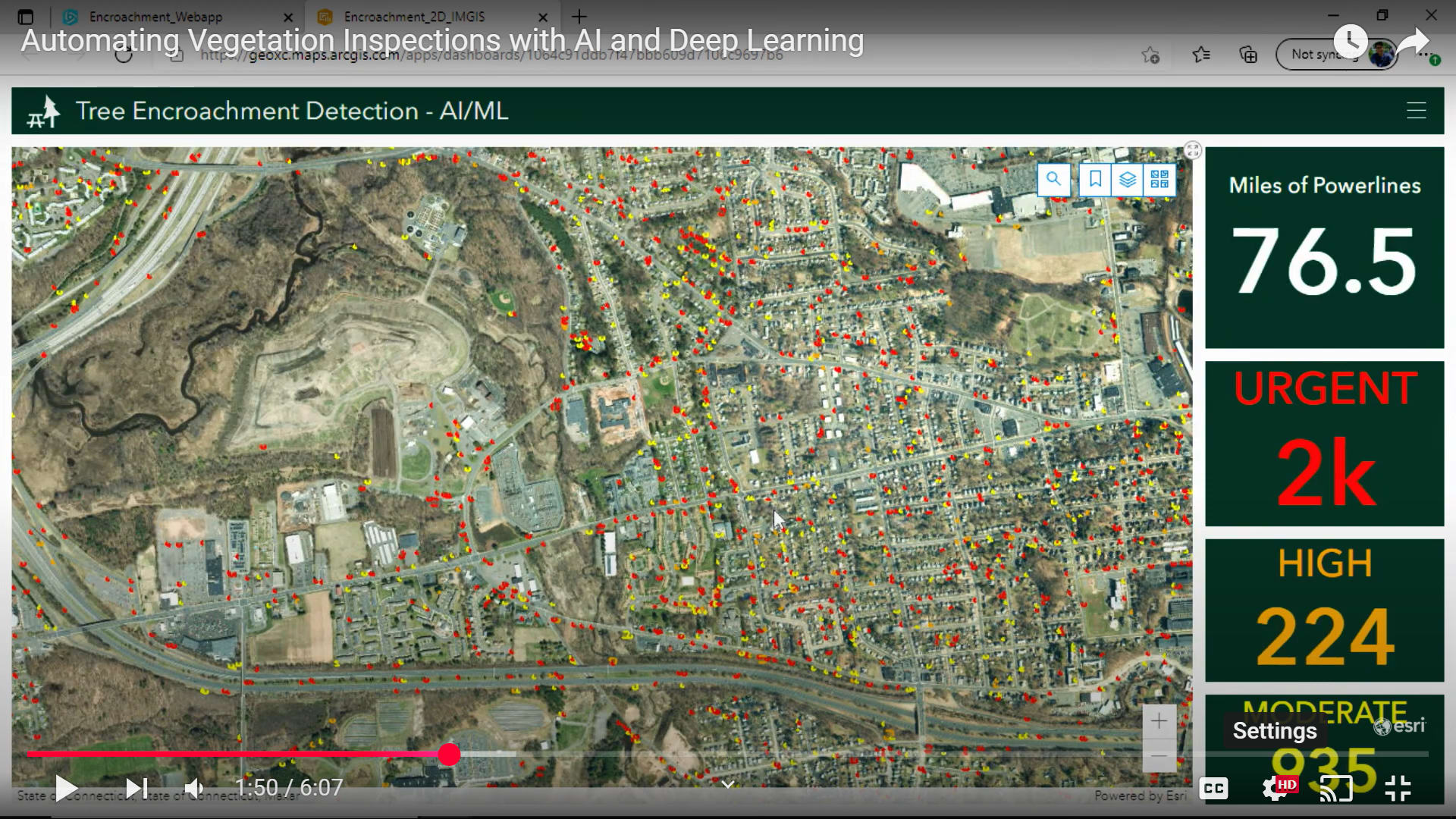
Video screenshot of ArcGIS Dashboard showing Tree Encroachment Detection using AI and machine learning (ML). Source: Automating Vegetation Inspections with AI and Deep Learning, 2021 Esri IMGIS presentation
3. Asset recognition and mapping
Keeping track of utility assets across large territories can be time-consuming. GeoAI simplifies this by using computer vision and deep learning to automatically identify and classify assets from imagery like LiDAR. This speeds up asset mapping, improves data accuracy and reduces the need for manual work. With better data and faster updates, utilities can make smarter decisions and keep their infrastructure records up to date.
Interactive ArcGIS StoryMaps story showing how utilities use LiDAR to map power lines and surrounding infrastructure, enhancing asset visualization and planning. Source: From Point Clouds to Insights, Matthias Stängel, Esri Deutschland
4. Field operations efficiency
Field crews need tools that help them work faster and smarter. That’s where GeoAI comes in. GeoAI enhances field operations by improving data collection. For example, ArcGIS Survey123 (beta) includes AI-powered image detection that acts like a smart assistant. It can recognize asset types or conditions from photos and automatically fill in the form. This means less typing, fewer errors and quicker reporting. It also ensures that everyone is working with consistent, high-quality data, right from the field.
Demo of smart data collection in action: ArcGIS Survey123 with AI assistant for faster, smarter field reporting. Participate in the ArcGIS Survey123 Early Adopter beta program
Summarizing the benefits of integrating GeoAI with ArcGIS
Adopting GeoAI is more than a technological upgrade, it’s a strategic shift that transforms how utility organizations operate. By integrating GeoAI into the ArcGIS System, utilities can unlock a wide range of benefits:
- Reduce infrastructure risk through predictive analysis of very large volumes of data.
- Increase efficiency in field data collection and automated asset recognition.
- Enhance situational awareness by combining multiple data sources for deeper insights.
- Automate routine tasks, freeing up valuable resources for higher-priority work.
The Esri ArcGIS system brings together machine learning, deep learning, spatial analysis and AI-powered field tools like smart forms. These capabilities help organizations automate processes, uncover patterns and make faster, smarter decisions rooted in location intelligence.
And we’re just getting started. GeoAI is changing how utilities work, helping teams move from reactive to proactive decision-making. As this technology continues to evolve, it will empower utilities to operate more safely, efficiently and sustainably than ever before.
To learn more: esri.ca/utilities