Flourishing Communities: New Dashboard Reveals What Helps Canadians Thrive
What does it mean for a community to truly flourish? Discover how cutting-edge research and GIS technology are helping Canadians turn health data into meaningful action for stronger, more equitable communities.
To build effective health systems, reduce inequities, and ensure long-term sustainability, we must first understand the people these systems are designed to serve. Factors such as demographics, behaviours, social and environmental conditions, and overall health all shape the needs of a population. This understanding is at the heart of the work being done at the Population Health Analytics Laboratory, housed within the University of Toronto’s Dalla Lana School of Public Health (DLSPH).
Understanding What Makes Canadian Communities Flourish
As part of these efforts, award-winning researcher Laura Rosella, PhD, and her team conducted the Canadian Community Flourishing Survey. This national initiative was designed to reflect the voices of Canadian communities and track progress on what it means to flourish. Surveying thousands of residents across the country, it explored the personal and environmental factors that influence wellbeing, including individual health and mood, as well as broader community and social conditions.
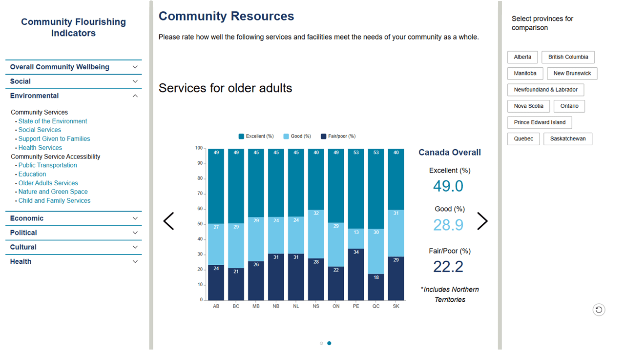
How well is your community being served? Canadians weigh in on local services and facilities in this revealing snapshot of public sentiment — just one of many interesting insights you can explore in the dashboard.
Turning Data into Action
But with so much rich data and insights locked in a survey, it was critical that the data could be easily reviewed and understood. This is where Esri Canada comes in. We’re proud to announce the launch of the Canadian Community Flourishing Dashboard — a public-facing tool designed to make unique health data accessible and actionable.
Built with ArcGIS Experience Builder and leveraging data from the survey, this public-facing site gives a clear view into community values, desires, and behaviours across Canada. It’s designed to help researchers, policymakers, and communities understand and act on the social determinants of health that shape wellbeing across Canada.

This section of the dashboard allows you to compare survey responses across the different provinces and territories in Canada.
Key features include:
- Interactive visualizations of community strengths and areas for improvement.
- Accessible health data for public health professionals, researchers, and community organizations.
- Support for future data collection and expanded functionality in upcoming releases.
The first release is live now, with plans to refine the user experience and add more granular maps in the future.
Our Mission and Partnerships
This initiative is one of many projects embedded in a 3-year strategic collaboration with Esri Canada and the Dalla Lana School of Public Health. The dashboard demonstrates how GIS technology can drive social impact and create meaningful change.
By making research health data easier to explore, we’re helping promote health equity, community resilience, and informed decision-making across Canada. View other Esri Canada health collaborations here.
Want to learn more? We invite you to watch our webinar Geospatial Technology: The New Approach for Closing Gaps in Health Equity, where you can learn how Unity Hospital’s REACH Nexus uses GIS tools to help connect priority populations to sexually transmitted and blood-borne infection (STBBI) care services.