An ArcGIS Enterprise deployment tailored to your needs with Kubernetes
Do you want an ArcGIS Enterprise deployment that lives in the cloud? No need to search further with the cloud-native ArcGIS Enterprise on Kubernetes.
ArcGIS Enterprise on Kubernetes is the newest type of ArcGIS deployment. Based on Kubernetes, it is designed to be cloud native, optimize scalability, be as resilient as possible and be as easy to manage as possible. But how does it achieve all these feats?
1. It’s cloud native
ArcGIS Enterprise on Kubernetes is cloud native, but ArcGIS Enterprise on Azure and ArcGIS Enterprise on AWS already exist, so what’s the difference? Well, it’s the “native” in cloud native. ArcGIS Enterprise on Azure and ArcGIS Enterprise on AWS are ArcGIS Enterprise deployments that are deployed on the cloud instead of an on-premises server. All the components are the same as ArcGIS Enterprise on Windows or Linux. ArcGIS Enterprise on Kubernetes, however, has a whole new architecture based on containers and microservices.
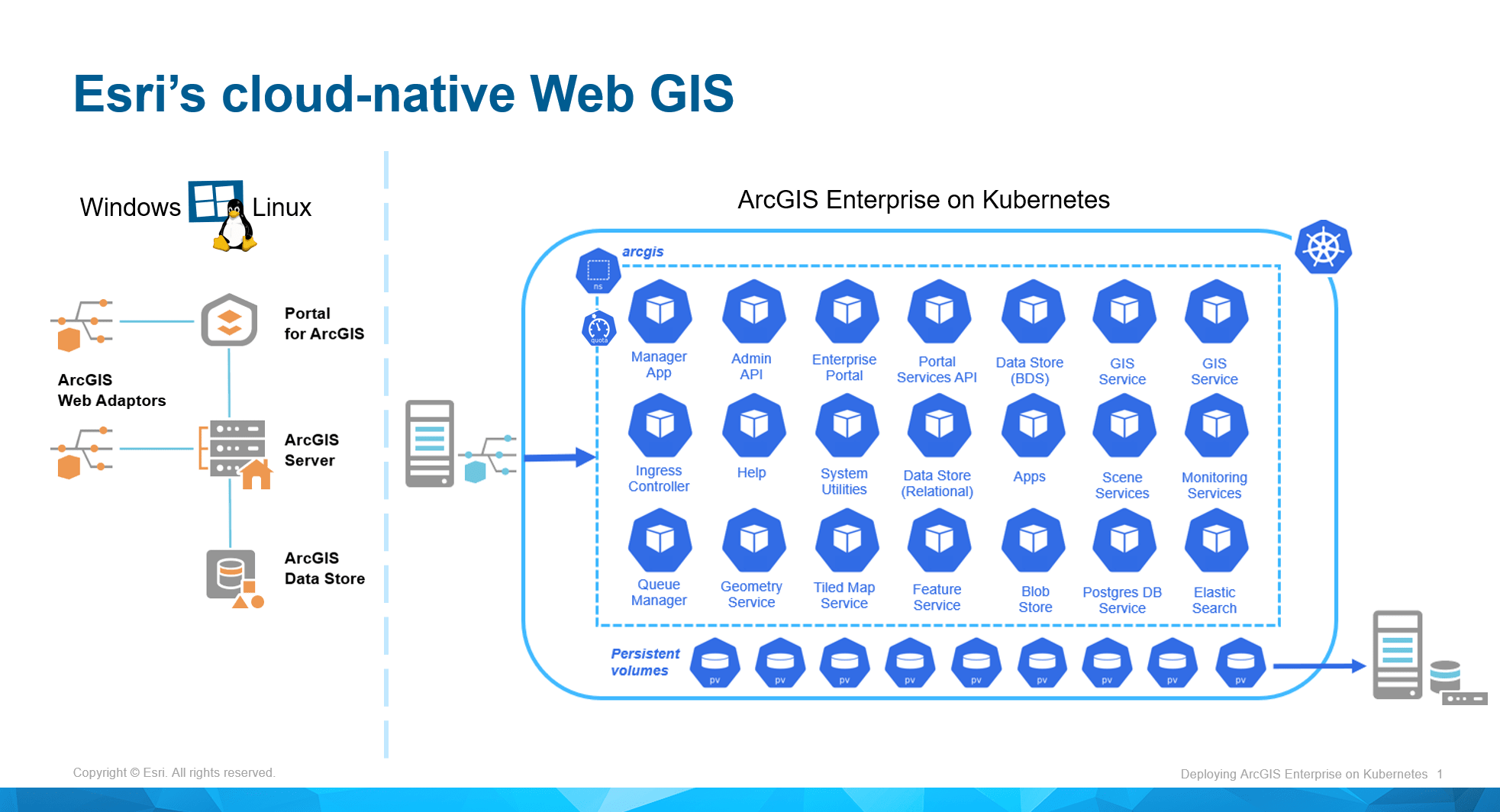
The difference in architecture between ArcGIS Enterprise on Windows and Linux and ArcGIS Enterprise on Kubernetes.
2. It optimizes scalability
One of the main advantages of Kubernetes’ architecture is that it can be configured to automatically scale its containers and microservices to fit the demand at a specific time, depending on the available resources. At that point, you may remember that with ArcGIS Server we can already do this kind of manipulation with dedicated pooling instances. So why is ArcGIS Enterprise on Kubernetes different?
ArcGIS Enterprise on Kubernetes can automatically scale everything up and down—not just web services. The unique components that exist in ArcGIS Enterprise on Windows and Linux don’t in ArcGIS Enterprise on Kubernetes. There are only containers and pods that can be scaled. So, if there is an influx of demand, let’s say map visualization, then ArcGIS Enterprise on Kubernetes will automatically create more containers to fit that specific need. When the demand is met, it will automatically decrease the number of containers to your minimal requirement.
The result is that if you want a high-availability ArcGIS deployment, ArcGIS Enterprise on Kubernetes is the perfect solution for you.
3. It allows you to be as resilient as possible
In the same vein as the previous point, ArcGIS Enterprise on Kubernetes has a control panel that will automatically manage your deployment’s scalability, but in doing so will also manage the health of the pods and containers. This means that if there is an issue in one of these areas, ArcGIS Enterprise on Kubernetes will automatically spin up another one taken from a docker image. All of this takes place without needing that much manipulation and maintenance from a GIS specialist.
4. It’s as easy to manage as possible
ArcGIS Enterprise on Kubernetes is a lot easier to manage than ArcGIS Enterprise on Windows and Linux. How is this possible? It’s simple: like we saw previously, the old components (Portal for ArcGIS, ArcGIS Server, ArcGIS Web Adaptor and ArcGIS Data Store) don’t exist within ArcGIS Enterprise on Kubernetes, so we don’t have to manage different software packages—only pods and containers.
So, if we want to update ArcGIS Enterprise on Kubernetes, we first create a backup (best practice, just in case), ensure we have the necessary licenses, then run a preupdate script that will perform any necessary steps that cannot be done by existing pods. Once that script is done running, you can simply click on the update button in the ArcGIS Manager interface and the update will run. Depending on the pods and containers available, it can run either a blue-green update or a rolling update. There won’t be any loss of functionality or service: the deployment will update while in production.
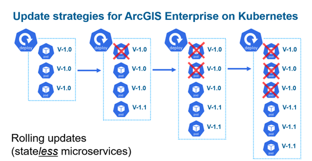
Example of rolling updates in ArcGIS Enterprise on Kubernetes
Another main advantage of ArcGIS Enterprise on Kubernetes that makes it easy to manage is that the interface is different. Sure, the main portal interface is the same, so end users won’t see a difference. But for the administrator, it’s another ballgame. Gone is the portaladmin interface, gone is ArcGIS Server Manager; in lieu of both of these, we have ArcGIS Manager, a brand-new interface that centralizes all the administrative tasks from managing services to updates.
If you’d like to take a deeper dive into the cloud-native world of ArcGIS Enterprise on Kubernetes or prepare for a deployment of your own, or if you have specific questions about what moving to Kubernetes might require, consider enrolling in Esri Canada’s in-depth, instructor-led training session “Deploying ArcGIS Enterprise on Kubernetes”. You’ll walk away with the knowledge you’ll need to install, configure and scale high-availability enterprise GIS native to the cloud.
Want to stay informed about all the latest training opportunities at Esri Canada? Visit Esri Canada’s Communication Preference Centre and select the “Training” checkbox to get a monthly roundup straight to your inbox.