How Great Basemaps Help Canadian Communities Prepare, Protect and Rebuild
Watch Video
Watch Video
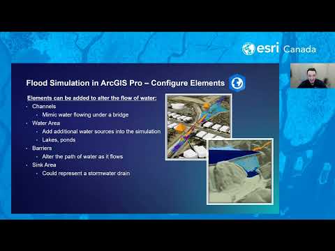
In this webinar, we’ll explore practical workflows for visualizing flood data and creating interactive maps that illustrate potential flood extents and impacts. You’ll learn how ArcGIS Solutions can a
Watch Video
How geospatial tools help Canadian communities reduce wildfire risk, especially in the WUI, before flames arrive.
View
Enhance NG911 data quality with fast address point creation and smooth road renaming in NG911 Data Manager—built for accuracy, speed and reliability.
View
Stay ahead of the forecast with the Weather Engine app, created by Huntsville and Lake of Bays using the Community Map of Canada for real-time local weather conditions. Weather Engine
Watch Video
Stay ahead of the forecast with the Weather Engine app, created by Huntsville and Lake of Bays using the Community Map of Canada for real-time local weather conditions. Margaret Stead
Watch Video
Learn What’s Making Us Mappy this week with Dana McKee – Public Safety Hybrid Basemap Style.
Watch Video
Discover how to choose accessible colour schemes in ArcGIS Pro and use an Esri tool to create color ramps that support users with color vision deficiencies.
Watch Video
Here is the and curated authoritative Canadian content that you can use to analyze natural disasters to better prepare for the future.
View
The Viewshed analysis tool is a zero-credit tool in ArcGIS Online which uses Esri’s World Elevation Services in the background, requiring only a point Feature Class as input data.
Watch Video
Welcome to part five of Esri Canada's Address Manager instructional video series. In this session, we will explore how to create and edit road segments and establish emergency services boundaries.
Watch Video
Discover how Esri’s GIS technology helped this fire department reduce service calls. The Georgina Fire and Rescue Services Department (Georgina Fire) significantly reduced open-air burning incidents b
Watch Video
Explore the latest insights on climate change in Canada and discover resources to help understand and adapt to the challenges.
View
Discover the vital role that Esri’s GIS technology plays in wildfire management at the Regional District of Central Okanagan’s Emergency Operations Centres (EOCs). The District leverages GIS to develo
Watch Video
A look at ArcGIS Velocity, open data import and real-time spatial analysis
View
Halifax Regional Municipality assessed the harm caused by the Upper Tantallon wildfire with the help of Esri’s Disaster Response Program.
View
Connecting Assignment Types to the Assignments feature layer enhances your team’s ability to monitor workforce operations dashboards effectively.
View
Learn about the latest wildfire smoke forecast layer and other essential resources in the Living Atlas.
View
City of Edmonton shares its activities in getting GIS data compliant to next generation 9-1-1.
View
Indoor maps will dramatically improve 9-1-1 emergency response and safety of first responders, ultimately saving more lives
View
Loading More...